After several failed settlements made by the Spaniards,
the area was repopulated on April 12, 1823 and given the name of
port of "TAMPICO".
From that date onwards,
the port has been under the jurisdiction of the State of Tamaulipas.
A Government decree of November 12, 1824, declared
the new city a maritime harbor. This helped to attract settlers
from all parts of the world; this vigorous migration favored
the quick commercial and economic development of the port city.
In 1863 the Central Railroad Company, in charge
of building the first railway destination from San Luis Potosi
to TAMPICO, started the construction of several
of the port facilities, including breakwaters, wharves, dikes
and maritime traffic signs on the navigation channel, also dredged
to a depth of 28 ft.
The first wharf location was commissioned in 1870;
breakwaters, dikes and dredging were completed in 1889 whereas
loading facilities, including three warehouses and 4 wharves of
145 meters each, were commissioned in 1903.
About this time important oil fields started to be
commercially developed in the area, event that brought with it
a very substantial increase in general commerce to and from the region.
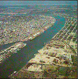
The Port of TAMPICO
extends, on both sides of the Rio Panuco,
for 22 kilometers, length considered from the breakwaters
in the Gulf of Mexico to a bridge Known as El Prieto, a bridge
that spans the river at that point inland.
Two parallel breakwaters form the port entrance on the Gulf.
The north breakwater in 1,340 meters long and the one to the south
is 1,455 long; there is also a 165 meters long jetty on the south,
a distance of 330 meters separates the breakwaters.
The depth of the navigation channel varies in accordance
with terminal needs.
 Return